21 Sep, 2014
Finished
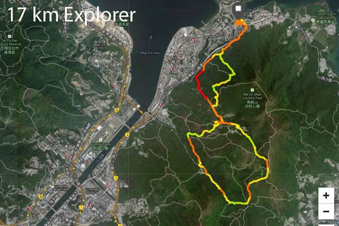
2014 - Double Cove Sai Kung 2 Ridges 迎海西貢雙嶺


Course 比賽路線
3 different categories to choose from if you like road or trails.
8 km FUN Walk or Run - (Paved path and road suitable for road runners who like small hills) - Double Cove (Wu Kai Sha MTR) - Leung Yau Rd - Ma On Shan Tsuen Rd - Ma On Shan Tsuen Rd BBQ Picnic Area - Ma On Shan Tsuen Rd - Double Cove (Wu Kai Sha MTR) - 1 cp with water only
Map attached in Download PDF
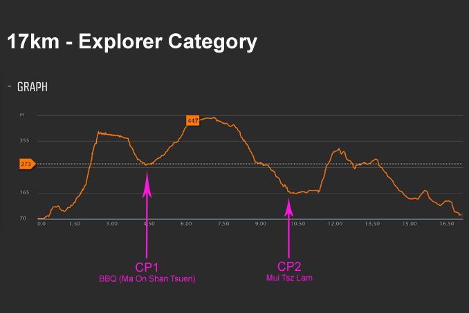
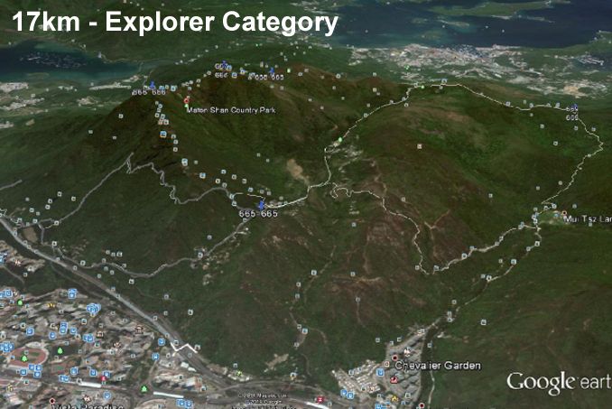
17 km - Explorer - (Technical trail race with steep climbs, stone path and mix of road) - Double Cove (Wu Kai Sha MTR) - Single track trail behind Main Public BBQ - Ma On Shan Country Trail - Maclehose trail - Mau Ping - Mui Tsz Lam - Ma On Shan Tsuen Rd - Leung Yau Rd - Double Cove (Wu Kai Sha MTR)
- 990m elevation gain / 989 elevation loss - Max elevation 404m. - 2 checkpoints at Ma On Shan BBQ and Mui Zhi Lam with water and bananas. (option of 3rd cp if you need as passing BBQ again with 4k left)
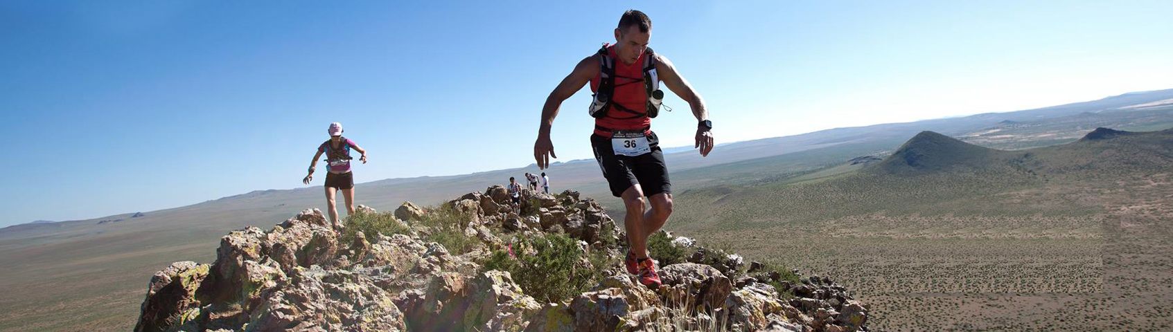
A technical and challenging route starting at Double Cove and running on path on mountain side of the Ma On Shan Bypass until a set of stairs going up a technically challenging and narrow single track trail for over a kilometer until a contour trail that comes out near a small pagoda above the main BBQ on Ma On Shan Tsuen Rd. Then heading up higher on the road until the end turns into the trail that meets the Maclehose trail and following until Mau Ping then right turn down technical stone trail to Mui Zhi Lam then along cement road catchwater 1km until end and right turn up dirt technical single track coming out near BBQ at Ma On Shan Tsuen Rd then following road down 2k to hairpin corner and right along same cement path you started on leading back to Double Cove. Recommend hiking not running unless experienced trail runners.
Map attached in Download PDF
GPX file - Double Cove SK 17km (suunto)
GPX file - Double Cove SK 17km (Garmin)
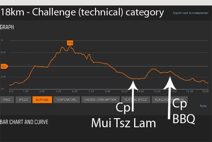
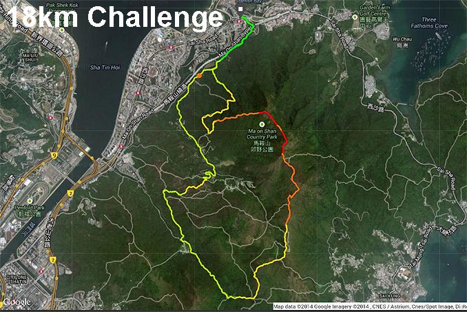
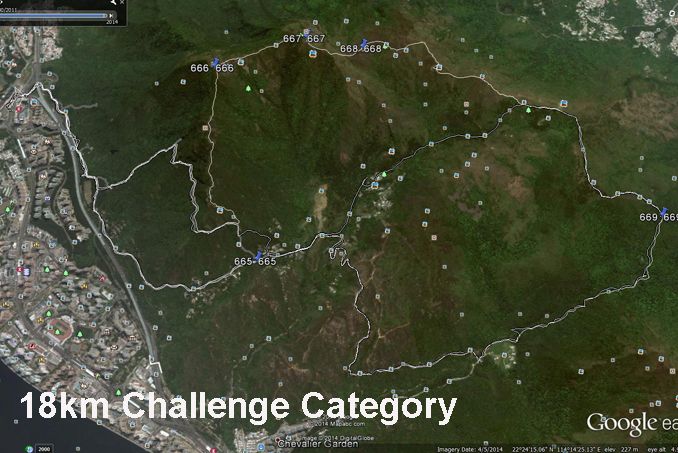
18 km Challenge - (Technical trail race with steep climbs all the way over actual Ma On Shan Peaks, stone path and mix of road) - Double Cove (Wu Kai Sha MTR) - Single track trail behind Main BBQ - Tiu Sha Ngam - The Hunch Backs (Ngau Ngak Shan) - Ma On Shan - Pyramid Hill (Tai Kam Chung) - Mau Ping - Mui Tsz Lam - Ma On Shan Tsuen Rd - Leung Yau Rd - Double Cove (Wu Kai Sha MTR)
-1259m elevation gain / 1226m elevation loss - Max elevation 705m - 2 checkpoints at Mui Zhi Lam & BBQ at Ma On Shan Tsuen Rd with water and bananas.
A technical and challenging route starting at Double Cove and running on path on mountain side of the Ma On Shan Bypass until a set of stairs going up a technically challenging and narrow single track trail for over a kilometer until a contour trail that comes out near a small pagoda above the main BBQ on Ma On Shan Tsuen Rd. Then heading up left turn to steep Hunchback and Ma On Shan ridge line the meet the Maclehose trail and following going over Pyramid Hill until Mau Ping then right turn down technical stone trail to Mui Zhi Lam then along cement road catchwater 1km until end and right turn up dirt technical single track coming out near BBQ at Ma On Shan Tsuen Rd then following road down 2k to hairpin corner and right along same cement path you started on leading back to Double Cove. Recommend hiking not running unless experienced trail runners.
Map attached in Download PDF
GPX file- Double Cove SK 2 Ridges 18km (suunto)
TRAINING IS NEEDED FOR Explorer and Challenge categories
Please make sure you do hill training before competing in this category as you will be climbing some of the biggest peaks in Hong Kong.
CUT OFF TIME
8 km - 3 hour cut-off with 2 hour cut-off at BBQ cp.
17 km - Total time will be 5.5 hours with a 4 hour cut off at Mui Zhi Lam (bus provided to MTR but will need Octopus card or small change to get back 2 MTR stops away.
18 km - same as 17 km but 4 hour cut-off at Mui Zhi Lam cp.
18 km - ONLY 100 RUNNERS ARE GIVEN PERMISSION FOR THIS SPECIAL CATEGORY SO YOU MUST EMAIL 2ridges@actionasiaevents.com with YOUR NAME AND RACE RESULT EXPERIENCE THAT YOU CAN COMPLETE THIS FULL COURSE WITHIN 4.5 HOURS. (example Lantau 2 Peaks finisher in 4 hours or under or other similiar mountain race).
道路/ 山路,3個不同賽程可供選擇。
8公里歡樂步行 / 跑 -(小徑,道路 - 適合步行/ 路跑人士)
路線:迎海 (烏溪沙馬鐵站)- 良友路 - 馬鞍山村路 - 馬鞍山村路燒烤場地 - 馬鞍山村路 - 迎海 (烏溪沙馬鐵站)
水站1個: 提供飲用水
左方Download PDF 內附賽事地圖檔案
17公里體驗組別 - (技術型賽道包含斜坡,石道等)
路線: 迎海 (烏溪沙馬鐵站)- 燒烤場後山徑- 馬鞍山郊遊徑- 麥里浩徑- 茅坪- 梅子林- 馬鞍山村路- 良友路 -迎海 (烏溪沙馬鐵站)
990米總攀升 / 989米總下降 - 最高攀升值404米。設兩水站: 馬鞍山村路燒烤場地 及 梅子林 (提供飲用水及香蕉)
迎海出發,技術型及富挑戰性路線,從馬鞍山山路前往梯級往上走。進入狹道小徑約一公里,到達馬鞍山村路燒烤場上的小亭。再往前走途經麥理浩徑,再沿茅坪右轉石道入梅子林。沿引水道約一公里到盡頭,接著右轉山泥小徑返回馬鞍山村路燒烤場,下坡約2公里然後沿右邊石屎路原路返回迎海- 終點。建議經驗較淺參賽者可以遠足方式完成賽事。
左方Download PDF 內附賽事地圖檔案
18公里挑戰組別 - (技術要求高之路程全程沿馬鞍山脊,石徑等各種路徑)
路線:迎海 (烏溪沙馬鐵站) - 燒烤場後山徑 - 吊手岩- 牛押山- 馬鞍山- 大金鐘- 茅坪- 梅子林- 馬鞍山村路- 良友路- 迎海 (烏溪沙馬鐵站)
1259米總攀升 / 1226米總下降 - 最高攀升值705米。設2水站: 梅子林 及 馬鞍山村路 (提供飲用水及香蕉)
體驗及挑戰組別,均須賽前鍛鍊。
請確保賽事前進行山訓/操山練習,做好賽前準備。這是香港數一數二的山嶺。
賽事截跑時限
8公里- 全程限時為3小時,燒烤場水站截跑時間為2小時
17公里- 全程限時為5.5小時,梅子林水站截跑時間為4小時(被截停之跑手,大會提供巴士接戴往指定馬鐵站)。請注意必須帶備八達通卡/ 輔幣,自行轉乘馬鐵(2個車站)返回賽事終點。
18公里- 全程限時為5.5小時,梅子林水站截跑時間為4小時(被截停之跑手,大會提供巴士接戴往指定馬鐵站)。請注意必須帶備八達通卡/ 輔幣,自行轉乘馬鐵(2個車站)返回賽事終點。
18公里-100 名限定參賽名額 – 參賽人士必需透過電郵 2ridges@actionasiaevents.com 提交有關證明過往越野賽事完成時間紀錄,以便大會發出此組別「賽事登入認證碼」或英文翻譯為”Authorized Entry Code”,便可進行賽事登記。(例: Lantau 2 Peaks 賽事之21公里組別,於4小時內完成 或 其他 15-20 公里或以上之山跑賽事完成時間紀錄)。
以上內容以網頁內之英文版本為準


/Goodman300x100px-v2.jpg)
/CBREMKC_9735_HK_Logo web banner-01.jpg)
/RoyalInt300100banner.jpg)
/AX_web_300px_001.png)
/C3Fit.jpg)