07 Dec, 2013
Finished
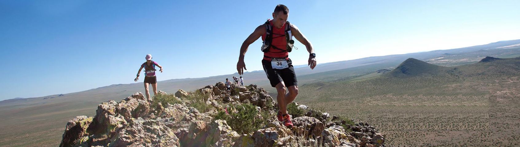
2013 - MSIG Lantau 50 - HK 50 Series


Course 比賽路線

27 km - 1594 elevation gain, 1598 elevation loss, Total gain/loss 3192m - Max elevation 684m..

50km - 2607m elevation gain, 2611 elevation loss with total gain/loss 5218m. Max elevation 684m.

14 km - 884m Elevation gain, 880 elevation loss, Total gain/loss 1764m - Max elevation 441m..
MAPS UPLOADED ON LEFT OF THIS PAGE UNDER DOWNLOAD PDF
Course marking - Yellow A5 size signs and bright pink/bright orange ribbons
14 km (13.95 km - 884m Elevation gain, 880 elevation loss, Total gain/loss 1764m - Max elevation 441m) - 1 Water CP - http://connect.garmin.com/activity/194102178
Starts at Auberge Hotel, North Plaza in Discovery Bay, Lantau, Head thru underpass until you hit large roundabout with fountain, turn left and cross road to ‘Neo Horizon’ building. Go behind Neo Horizon and climbs up single track trail to Yi Pak Au (1.4 km - 160m) and steadily climbs up to Lau Fa Tung (378m). You stay on the main trail which converses around the North side of 465m Lo Fu Tau (2.8 km - 441m) and eventual views of the west side of the DB golf course and arriving at Mong To Au Olympic Trail junction (6.1 km - 178m) by wooden hut & AFCD map board and doing a right turn. Stay on Olympic trail heading in Pak Mong direction until you reach the new public toilet in front of Ngau Kwu Long village (7.8 km - 12m) which is almost at sea level and is the only water check point for the 14km category (Bonaqua & Aquarius). Take a right turn here towards Tai Ho Wan following sign on ground saying Tin Liu Tsuen. Immediately BEFORE path for 100m and do right turn at end of handrail on the right short cutting on grass trail for 10m until other path turning right again towards Tin Liu village. Only walk 40m and you will arrive in Tin Liu Tsuen village. Just BEFORE the third building (first Double story house) turn left -
– you need to be almost touching the building – and head behind the house. The trail entrance starts between 2 big trees trees (beware in training as track is quite overgrown). There are several bird boxes on the left just after the trail entrance. Follow the single track trail that goes all the way up the mountain ridge behind. Hike up single track until you reach ridge where it flattens out (9.1 km - 268m) and do continue to follow single track trail along ridge steadily climbing but runable until you reach big rock outcrop on junction that hits the same trail you came down earlier. (10 km - 340m). Turn LEFT here at this big rock and follow same trail back around Lo Fu Tau (11.1 km - 441m), Lau Fa Tung (11.5 km - 378m) and Yi Pak Au (12.6 km - 160m) and back down trail to DB. Turn left on main road in DB crossing to other side and run thru underpass staying on sidewalk until you reach the Auberge Hotel in the North Plaza where the finish is the same as the start.
27 km (27.33 km - 1594 elevation gain, 1598 elevation loss, Total gain/loss 3192m - Max elevation 684m) - 2 Water CPs - http://connect.garmin.com/activity/194870495
Starts at Auberge Hotel, North Plaza in Discovery Bay, Lantau, climbs up single track trail near left side of DBay tunnel to Yi Pak Au (1.4 km - 160m) and steadily climbs up to Lau Fa Tung (378m). You stay on the main trail which converses around the North side of 465m Lo Fu Tau (2.8 km - 441m) and eventual views of the west side of the DB golf course and arriving at Mong To Au Olympic Trail junction (6.1 km - 178m) by wooden hut and doing a right turn. Stay on Olympic trail heading in Pak Mong direction until you reach the new public toilet in front of Ngau Kwu Long village (7.8 km - 12m) which is almost at sea level and is the first water check point for the 28km category (Bonaqua & Aquarius). Take a LEFT turn here towards Pak Mong and stay on road until ancient chimney on left side after another set of public toilets by Pak Mong village (8.8 km) and turn left on single track trail here. Follow trail all the way up and around the 482m Por Kai Shan (9.1 km) staying on main trail towards Sunset Peak passing 706m Lin Fa Shan and reaching a max elevation of 682m before descending to the Lantau trail junction of the Sheung Tung Au (14.6 km - 613m) where you will do a LEFT turn towards Nam Shan. Descend the Lantau trail until you reach the bottom of the stairs just before Nam Shan and continue straight ahead staying on the main trail until you reach the Nam Shan picnic tables and wooden hut (14.6 km - 132m) where cp 2 will be (Bonaqua & Aquarius).Take a LEFT turn on the grass here and follow grass park to the bottom passing the picnic tables and you will see a trail at the end going to Luk Tei Tong in Mui Wo (18.4 km - 10m). You will come out behind a house in Luk Tei Tong and the trail winds it way around the house for 30 meters before arriving on the main cement road where you will do a LEFT turn heading towards the Olympic trail that will take you thru Mui Wo past Nim Po Tsuen heading North and up the Olympic trail stairs passing the waterfall. Carry on the Olympic trail until you reach the same junction with the wooden hut and AFCD map board that you came out of earlier (21.6 km - 178m) and turn RIGHT. Follow same way back passing the golf course and big rocky outcrop (23.8 km - 335m) and follow same trail back around Lo Fu Tau (25 km - 441m), Lau Fa Tung (25.4 km - 378m) and Yi Pak Au (26.6 km - 160m) and back down trail to DB. Turn left on main road in DB crossing to other side and run thru underpass staying on sidewalk until you reach the Auberge Hotel in the North Plaza where the finish is the same as the start.
50 km (49.9 km) -5 Water CPs -
2607m elevation gain, 2611 elevation loss with total gain/loss 5218m. Max elevation 684m. Min elevation 2m. - http://connect.garmin.com/activity/195209285
Starts at Auberge Hotel, North Plaza in Discovery Bay, Lantau, climbs up single track trail near left side of DBay tunnel to Yi Pak Au (1.4 km - 160m) and then up to Lau Fa Tung (378m). You stay on the main trail which converses around the North side of 465m Lo Fu Tau (2.8 km - 441m) and eventual views of the west side of the DB golf course and arriving at Mong To Au Olympic Trail junction (6.1 km - 178m) by wooden hut and doing a right turn. Stay on Olympic trail heading in Pak Mong direction until you reach the new public toilet in front of Ngau Kwu Long village (7.8 km - 12m) which is almost at sea level and is the first water check point for the 28km category (Bonaqua & Aquarius). Take a LEFT turn here towards Pak Mong and stay on road until ancient chimney on left side after another set of public toilets by Pak Mong village (8.8 km) and turn left on single track trail here. Follow trail all the way up and around the 482m Por Kai Shan (9.1 km) staying on main trail towards Sunset Peak passing 706m Lin Fa Shan and reaching a max elevation of 682m before descending to the Lantau trail junction of the Sheung Tung Au (14.6 km - 613m) where you will do a LEFT turn towards Nam Shan. Descend the Lantau trail until you reach the bottom of the stairs just before Nam Shan and continue straight ahead staying on the main trail until you reach the Nam Shan picnic tables and wooden hut (14.6 km - 132m) where cp 2 will be (Bonaqua & Aquarius).
After water cp2 turn right and cross the main road to other side and take main trail up until you reach the Lantau trail where you will do RIGHT turn and go over the ridge passing a helicopter pad (262m) and downhill until you reach Shap Long Kau Tsuen at the main Chi Ma Wan entrance with big wooden arch (20 km - 50m) on Chi Ma Wan Road. There is a water cp here BUT it is for your return trip only so you can not use it. Continue straight thru the arch going LEFT inside and going to the campsite area at the back around 200m until you cross a little river stream on left side. (Use map for this area on recce). Stay on this single track trail which contours all the way around to the reservoir. Don't take the trail down to Shap Long Chung Hau as you want to go straight as the trail finishes on a little old cement road (Right turn) and reservoir is around 300m which you will cross staying on main trail until as trail sign starting a smaller Chi Ma Wan loop (22.9 km - 129m) that goes to the 5 km little chi ma wan loop and arrives at Lung Mei (dragon statue) for the next water cp 3 (27.8 km - 121m). Now you will do a LEFT turn and continue on the longer Chi Ma Wan country trail which is also a mountain bike trail (so watch out for bikers) and stay on main trail (don't take any turns) until you arrive back at main Chi Ma Wan entrance again where there is water cp4 (36.3 km - 50m). Cross the Chi Ma Wan Road and continue back up the same stairs and trail you came from earlier at Nam Shan. When you arrive at Nam Shan this will be your last water cp5 (39 km - 132m) at the same wooden hut you passed earlier.
Take a RIGHT turn on the grass here and follow grass park to the bottom passing the picnic tables and you will see a trail at the end going to Luk Tei Tong in Mui Wo (40.1 km - 10m). You will come out behind a house in Luk Tei Tong and the trail winds it way around the house for 30 meters before arriving on the main cement road where you will do a LEFT turn heading towards the Olympic trail that will take you thru Mui Wo past Nim Po Tsuen heading North and up the Olympic trail stairs passing the waterfall. Carry on the Olympic trail until you reach the same junction with the wooden hut and AFCD map board that you came out of earlier (43.5 km - 178m) and turn RIGHT. Follow same way back passing the golf course and big rocky outcrop (45.7 km - 335m) and follow same trail back around Lo Fu Tau (46.9 km - 441m), Lau Fa Tung (47.3 km - 378m) and Yi Pak Au (48.5 km - 160m) and back down trail to DB. Turn left on main road in DB crossing to other side and run thru underpass staying on sidewalk until you reach the Auberge Hotel in the North Plaza where the finish is the same as the start.
(Cut-offs) - There will be a cut-off at Nam Shan for 50km participants. This means if you do not arrive at Nam Shan by a certain time, you will not be able to do the Chi Ma Wan circuit and directed to continue the 27km course. There also might be a cut-off at Lung Mei (the dragon) on Chi Ma Wan which will confirmed soon.
(Cut-offs) –
CP1 - Pak Mong (7.8km) – 9am (2 hrs) (or 10:00 for 27km and 10:30am for 14km)
CP2 - Nam Shan (17.6km)- 11:30 am (4.5 hrs) (or 1pm for 27km)
CP3 - Lung Mei (27.8km) – 1pm (6 hrs)
CP4 - CMW entrance/exit (36.3km) – 2:30pm (7.5 hrs)
CP5 – Nam Shan (39km) – 3:30pm (8.5 hrs)
Mui Wo – Olympic Trail (41km) – 4:30pm (9.5 hrs)
Finish – 7pm (12 hrs)
Bonaqua water, bananas, spagetti and bread rolls at finish in Auberge Hotel ballroom for all finishers.
Water checkpoint - Bonaqua mineral water, bananas and oranges.
比賽賽道: (詳細賽道資料,請參考英文版本內容)
14 公里
(13.95 公里 – 累積884米攀升高度,累積880米下降高度, 總海拔差距1764米 。最高海拔攀升 441米) – 設置水站1個
愉景灣酒店,北翼商場起步 à老虎頭(465米)à 望渡坳 à 右轉入奧運徑(白芒方向) à田寮村 à牛牯塱(水站, 7.8公里) 右轉à大蠔à老虎頭 à 愉景灣酒店終點
27公里
(27.33 公里 -累積1594米攀升高度,累積1598米下降高度,總海拔差距3192米。最高海拔攀升684米) –設置水站2個
愉景灣酒店,北翼商場起步à老虎頭(465米)à 望渡坳 à 右轉入奧運徑(白芒方向) à牛牯塱(第1水站, 7.8公里) 左轉à 白芒 à 雙東坳à南山 (第2水站,17.6公里) à 鹿地塘à窩田 à望渡坳 à老虎頭 à 愉景灣酒店終點
50 公里
(49.9 公里 -累積2607米攀升高度,累積2611米下降高度,總海拔差距5218米。最高海拔攀升684米) – 設置水站5個
愉景灣酒店,北翼商場起步à 老虎頭(465米)à 望渡坳 à 右轉入奧運徑(白芒方向) à 牛牯塱(第1水站,7.8公里) 左轉à白芒 à 雙東坳à南山 (第2水站,17.6公里) à十塱舊村(芝麻灣入口) à芝麻灣半島 à 龍尾(第3站, 27.8公里) à十塱舊村(芝麻灣入口) (第4水站, 36.3公里) à 南山(第5水站, 39公里) à鹿地塘à窩田 à望渡坳 à老虎頭 à 愉景灣酒店終點
(大會中段停截時間)
50公里參賽者注意,大會於南山設置停截時間,若參賽者於限時內未能抵達該檢查站,將終止前進並直接經27公里賽道繼續賽事,返回終點。另外,龍尾(芝麻灣)亦同樣設置停截時間,時間有待確定。
第1檢查站 / 水站 – 白芒 (7.8公里) – 早上9時正 (開賽2小時)
第2檢查站 / 水站 – 南山(17.6公里) – 早上11:30 (開賽4.5小時)
第3檢查站 / 水站 – 龍尾(27.8公里) – 下午1時正 (開賽6小時)
第4檢查站 / 水站 – 芝麻灣入口(36.3公里) – 下午2:30 (開賽7.5小時)
第5檢查站 / 水站 – 南山(39公里) – 下午3:30 (開賽8.5小時)
梅窩 – 奧運徑 (41公里) -下午4:30 (開賽9.5小時)
終點 - 晚上7時正 (開賽12小時)
Bonaqua 飲用水及提供賽後膳食服務
水站- 飛雪礦物質水,香蕉
以上內容以網頁內之英文版本為準


/Goodman300x100px-v2.jpg)
/CBREMKC_9735_HK_Logo web banner-01.jpg)
/RoyalInt300100banner.jpg)
/AX_web_300px_001.png)
/C3Fit.jpg)