15 Feb, 2020
Finished
2020 - Sai Kung 50 (postponed)


Course 比賽路線
Three Distances 3個距離
54Km (54.5Km) - elevation gain 2857m & elevation loss 2857m - 11 hour cut-off
22Km (22.5Km) - elevation gain 1083m & elevation loss 1083m - 8 hour cut-off
12Km (12.9Km) - elevation gain 641m & elevation loss 641m - 5 hour cut-off
54公里 (54.5公里) - 總爬升2857米,總下降2857米 – 限時 11小時
22公里 (22.5公里) - 總爬升1083米,總下降1083米 – 限時 8小時
12公里 (12.9公里) - 總爬升641米,總下降641米 – 限時 5小時
MAPS UPLOADED ON LEFT OF THIS PAGE UNDER DOWNLOAD PDF.
地圖可於左方"Download PDF"下載。
Start & Finish - Pak Tam Chung, Sai Kung
起點及終點 - 北潭涌, 西貢
Course marking - Yellow A4 size signs and bright orange ribbons
路線指示 – 黃色A4尺碼路標及橙色絲帶
54Km公里 (54.5Km公里)
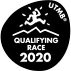
UTMB Qualify race - Finisher of 54Km race can get 3 points for ITRA Endurance Point
UTMB 資格賽 - 完成54公里賽事可取得ITRA分數(ITRA Endurance Point) - 3分
Please find the details of certified tracks below. 有關認証路線請參閱以下連結。
https://tracedetrail.fr/en/trace/trace/89942
Elevation gain 2857m & elevation loss 2857m - 11 hour cut-off
總爬升2857米,總下降2857米 – 限時 11小時
Start time: 6:30AM
起步時間:早上6:30
Pak Tam Chung - Tai Mong Tsai Rd - Tai Cham Koi (408m) - Lok Wu Trail (293m) - Chek Keng (CP1) - Tai Long Au (154m) - Tai Wan (sea level) - Ham Tin – Lo Tei Tun – Chui Tung Au – Sai Wan Shan (314m) – Lung Ke (sea level) – East Dam (CP2) – Pak Lap – Tin Hau Temple – Chau Tsai - Sai Kung Man Yee Rd – West Dam – Sheung Yiu Country Trail – Pak Tam Rd (CP3) – Pak Tam Country Trail – Pak Tam Au – Ngau Yee Shek Shan (408m) – Cheung Sheung – Wa Mei Shan – Maclehose Trail/Yung Pak Corridor junction (CP3A) - Kai Kung Shan (399m) – Sai Sha Road (CP4) – Maclehose Trail/Yung Pak Corridor junction (CP4A) - Pak Tam – Pak Tam Chung
北潭涌 - 大網仔路 - 大枕蓋(408米) - 鹿湖郊遊徑 (293米) - 赤徑 (檢查點1) - 大浪坳 (154米) - 大灣 (海平線) - 鹹田 - 螺地墩 - 吹筒坳 - 西灣山 (314米) - 浪茄 (海平線) - 東壩 (檢查點2) - 白腊 - 天后廟 - 洲仔 - 西貢萬宜路 - 西壩 - 上窰郊遊徑 - 北潭路 (檢查點3) - 北潭郊遊徑 - 北潭坳 - 牛耳石山 (408米) - 嶂上 - 畫眉山 - 麥徑/榕北走廊連接點 (檢查點3A) - 雞公山 (399米) - 西沙路 (檢查點4) - 麥徑/榕北走廊連接點 (檢查點4A) - 北潭 - 北潭涌

|
From 由 |
To 去 |
Distance (Km) 距離 (公里) |
Accumulated 累計距離 (公里) |
Elevation 攀升 (米) |
Accumulated 累計攀升 (米) |
Elevation 下降 (米) |
Accumulated 累計下降 (米) |
|
Pak Tam Chung 北潭涌 |
ChekKeng 赤徑 |
7.9 |
7.9 |
473 |
473 |
481 |
481 |
|
ChekKeng 赤徑 |
East Dam 東壩 |
14 |
21.9 |
771 |
1244 |
723 |
1204 |
|
East Dam 東壩 |
Pak Tam Road 北潭路 |
14 |
35.9 |
383 |
1627 |
427 |
1631 |
|
Pak Tam Road 北潭路 |
Maclehose Trail/ 麥徑/榕北走廊 |
6.7 |
42.6 |
491 |
2118 |
322 |
1953 |
|
Maclehose 麥徑/榕北走廊 |
Sai Sha Road 西沙路 |
4.4 |
47 |
307 |
2425 |
411 |
2364 |
|
Sai Sha Road 西沙路 |
Maclehose Trail/ 麥徑/ |
4.4 |
51.4 |
414 |
2839 |
316 |
2680 |
|
Maclehose 麥徑/榕北走廊 |
Pak Tam Chung 北潭涌 |
3.1 |
54.5 |
18 |
2857 |
177 |
2857 |
|
CP 檢查點 |
Location 地點 |
Distance (Km) 距離 (公里) |
Cut Off Time 關門時間 |
Drink 飲品 |
Food 食物 |
|
CP1 檢查點1 |
ChekKeng 赤徑 |
7.9 |
上午9:00AM (2Hr小時30Min分鐘) |
Water 水 |
Orange, Banana 橙、香蕉 |
|
CP2 檢查點2 |
East Dam 東壩 |
21.9 |
上午11:30AM (5Hr小時) |
Water 水 |
Orange, Banana, Bread & Peanut Butter 橙、香蕉、花生醬麵麭 |
|
CP3 檢查點3 |
Pak Tam Road 北潭路 |
35.9 |
下午2:00PM (7Hr小時30Min分鐘) |
Water 水 |
Orange, Banana, Bread & Peanut Butter 橙、香蕉、花生醬麵麭 |
|
CP3A 檢查點3A |
Maclehose Trail/Yung Pak Corridor junction 麥徑/榕北走廊連接點 |
42.6 |
下午3:00PM (8Hr小時30Min分鐘) |
N/A (Timing only) 不提供 (只作計時) |
N/A (Timing only) 不提供 (只作計時) |
|
CP4 檢查點4 |
Sai Sha Road 西沙路 |
47 |
下午4:00PM (9Hr小時30Min分鐘) |
Water 水 |
Orange, Banana, Bread & Peanut Butter 橙、香蕉、花生醬麵麭 |
|
CP4A 檢查點4A |
Maclehose Trail/Yung Pak Corridor junction 麥徑/榕北走廊連接點 |
51.4 |
N/A 不設關門時間 |
N/A (Timing only) 不提供 (只作計時) |
N/A (Timing only) 不提供 (只作計時) |
|
Finish 終點 |
Pak Tam Chung 北潭涌 |
54.5 |
下午5:30PM (11Hr小時) |
Water 水 |
Orange, Banana, Hot meal/snack 橙、香蕉、熱食/小食 |
(50km) There will be a cut-off before dark near Pak Tam Chung. Participants who continue past CP4 section after 2:30pm MUST have a headlamp or torch with them and will not be allowed to continue if they don't carry. For your own safety we recommend all 50km runners to bring a headlamp and follow the mandatory equipment list under rules & regulations.
50公里組別因應天黑時間,設有額外關門限制,參加者如下午2:30之後到達檢查點4,必須帶備頭燈或電筒,才可繼續。基於安全理由,我們建議所有50公里參加者帶備頭燈,與及必須全程帶備規則與條款所列出的指定裝備。
22Km公里 (22.5Km公里)
UTMB Qualify race - Finisher of 22Km race can get 1 points for ITRA Endurance Point
UTMB 資格賽 - 完成22公里賽事可取得ITRA分數(ITRA Endurance Point) - 1分
Please find the details of certified tracks below. 有關認証路線請參閱以下連結。
https://tracedetrail.fr/en/trace/trace/89939
Elevation gain 1083m & elevation loss 1083m - 8 hour cut-off
總爬升1083米,總下降1083米 – 限時 8小時
Start time: 7:00AM
起步時間:早上7:00
Pak Tam Chung - Tai Mong Tsai Rd - Tai Cham Koi (408m) - Lok Wu Trail (293m) - Chek Keng (CP1) - Tai Long Au (154m) - Tai Wan Beach (sea level) - Ham Tin – Lo Tei Tun – Sai Kung Sai Wan Rd (CPSW) – Pak Tam Chung
北潭涌 - 大網仔路 - 大枕蓋(408米) - 鹿湖郊遊徑 (293米) - 赤徑 (檢查點1) - 大浪坳 (154米) - 大灣 (海平線) - 鹹田 - 螺地墩 - 西貢西灣路 (檢查點SW) - 北潭涌

|
From 由 |
To 去 |
Distance (Km) 距離 (公里) |
Accumulated Distance (Km) 累計距離 (公里) |
Elevation Gain (M) 攀升 (米) |
Accumulated Elevation Gain (M) 累計攀升 (米) |
Elevation Loss (M) 下降 (米) |
Accumulated Elevation Loss (M) 累計下降 (米) |
|
Pak Tam Chung 北潭涌 |
ChekKeng 赤徑 |
7.9 |
7.9 |
473 |
473 |
481 |
481 |
|
ChekKeng 赤徑 |
Sai Wan Road 西灣路 |
9.6 |
17.5 |
517 |
990 |
361 |
842 |
|
Sai Wan Road 西灣路 |
Pak Tam Chung 北潭涌 |
5 |
22.5 |
93 |
1083 |
241 |
1083 |
|
CP 檢查點 |
Location 地點 |
Distance (Km) 距離 (公里) |
Cut Off Time 關門時間 |
Drink 飲品 |
Food 食物 |
|
CP1 檢查點1 |
ChekKeng 赤徑 |
7.9 |
上午9:30AM (2Hr小時30Min分鐘) |
Water 水 |
Orange, Banana 橙、香蕉 |
|
CPSW 檢查點SW |
Sai Wan Road 西灣路 |
17.5 |
下午1:30PM (6.5Hr小時) |
Water 水 |
Orange, Banana, Bread & Peanut Butter 橙、香蕉、花生醬麵麭 |
|
Finish 終點 |
Pak Tam Chung 北潭涌 |
22.5 |
下午3:00PM (8Hr小時) |
Water 水 |
Orange, Banana, Hot meal/snack 橙、香蕉、熱食/小食 |
12Km公里 (12.9Km公里)
Elevation gain 597m & elevation loss 594m - 5 hour cut-off
總爬升641米,總下降641米 – 限時 5小時
Start time: 7:15AM
起步時間:早上7:15
Pak Tam Chung - Tai Mong Tsai Rd - Tai Cham Koi (408m) - Lok Wu Trail (293m) - Sai Kung Sai Wan Rd (CPSW) – Pak Tam Chung
北潭涌 - 大網仔路 - 大帎蓋 (408米) - 鹿湖郊遊徑 (293米) - 西貢西灣路 (檢查點SW) - 北潭涌

|
From 由 |
To 去 |
Distance (Km) 距離 (公里) |
Accumulated Distance (Km) 累計距離 (公里) |
Elevation Gain (M) 攀升 (米) |
Accumulated Elevation Gain (M) 累計攀升 (米) |
Elevation Loss (M) 下降 (米) |
Accumulated Elevation Loss (M) 累計下降 (米) |
|
Pak Tam Chung 北潭涌 |
Sai Wan Road 西灣路 |
7.9 |
7.9 |
551 |
551 |
409 |
409 |
|
Sai Wan Road 西灣路 |
Pak Tam Chung 北潭涌 |
5 |
12.9 |
63 |
641 |
232 |
641 |
|
CP 檢查點 |
Location 地點 |
Distance (Km) 距離 (公里) |
Cut Off Time 關門時間 |
Drink 飲品 |
Food 食物 |
|
CPSW 檢查點SW |
Sai Wan Road 西灣路 |
7.9 |
上午11:15AM (4Hr小時) |
Water 水 |
Orange, Banana, Bread & Peanut Butter 橙、香蕉、花生醬麵麭 |
|
Finish 終點 |
Pak Tam Chung 北潭涌 |
12.9 |
下午12:15PM (5Hr小時) |
Water 水 |
Orange, Banana, Hot meal/snack 橙、香蕉、熱食/小食 |
Course Design:
Designed by Michael Maddess (Race Director & Course Designer) who's organized over 190 events with Action Asia Events and one of the most experienced Race Directors in Asia. Michael Maddess an active trail runner, originally from Vancouver, Canada who was Race Director of the World Police Fire Games Triathlon in Canada before moving to Asia, has worked on over 17 Action Asia Challenges across Asia including Singapore, Malaysia, Taiwan, 3 Vietnam adventure races and 3 day stage marathon races, 1 Laos 100k ultra event, regional MSIG AA 50 series, 2 Himalayan Mtn Bike races, over 25 Action SPRINT HK adventure races, 8 Action Asia Off Road HK bike races, worked/competed in numerous other road races/triathlons including completing 3 Ironman triathlons (10hrs 52min), 1st runner-up in 100km trailwalker in 11hrs 16min (record for HK resident) 3x in 13 hrs 25 min, 12hrs 44min, 12hrs 39min, 3rd in HK100 in 12hrs 30min, winner of Sabah 3 day adv race 3x and 8th overall Gobi 250km race. He's also coached dragonboat, soccer and baseball teams, climbed to 15,000+ft Annapurna Basecamp, made it up to 5000m in Sichuan within 24hrs of getting off plane and jumps off bridges in Nepal for fun. If he's not outside designing a course, he's not having fun.
SUPPORT FROM FRIENDS – ONLY at cps allowed and no pacing allowed or support in between checkpoints (support must be within 100m of cps
朋友支援 - 支援只限於檢查點,配速員及檢查點之間的支援禁止。(支援只限檢查點100米範圍)
Cut-offs are subject to race discretion on race day as Race Director has final say.
關門時間 – 賽事總監在比賽當日擁有最終決定櫂
Insurance - The event has its own public liability insurance coverage, but we recommend that all participants get their own personal accident coverage to cover any personal accidents.
保險 – 本活動已購買公眾責任保險,但建議所有參加者購買個人意外保險以保障任何個人意外。
Medical - As this event involves going into the mountains we recommend all participants to have gone to a medical checkup before the event to make sure you are physically fit enough to handle this kind of physical challenge.
醫療 – 由於活動於山上進行,建議所有參加者進行醫療檢查,以確保身體狀況能應付有關挑戰。


/Goodman300x100px-v2.jpg)
/CBREMKC_9735_HK_Logo web banner-01.jpg)
/RoyalInt300100banner.jpg)
/AX_web_300px_001.png)
/C3Fit.jpg)