01 Oct, 2017
Finished
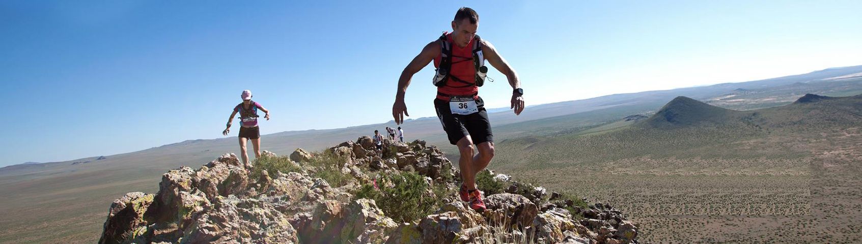
2017 - Action X Lantau 2 Peaks


Course 比賽路線
COURSES
15 km – Ngong Ping only or “half” peak - (757m elevation gain, 752m elevation loss - Max elev 564m)
A hill climb giving you a good workout thru Tung Chung and up the 360 rescue cement and wooden stair trail under the cable car towards Ngong Ping direction turning left on nice dirt single track trail around Nei Lek Shan (the highest elevation 564m) to the Ngong Ping water cp (458m), then down thru the Tei Tong Tsai monasteries thru Shek Mun Kap and following the walking track back to Citygate.
Water & bananas & oranges at cp1 and finish.
23 km – (23.6km) - Lantau 2 Peaks – (1977m elevation gain, 1971m elevation loss - Max elev 934m)
TRAINING IS NEEDED FOR 23 km 2 peaks category
Please make sure you do hill training before competing in this 23km category as you will be climbing some of the biggest peaks in Hong Kong.
A very tough and DIFFICULT hill climbing course that you need to train for. Tung Chung Citygate at sea-level, 360 Rescue trail, Nei Lek Shan contour trail (564m), Ngong Ping Water CP1 (458m), Lantau Peak - Fung Wong Shan (934m), Pak Kung Au Water CP2 (331m) , Sunset Peak -Tai Tung Shan (807m), Wong Lung Hang Country Trail stairs, Wong Lung Hang Road, Tung Chung Citygate.
Five (5 hrs) cut-off at Pak Kung Au will be in effect after start and those not making cut-off will be re-routed down Tung Chung Rd to Shek Mun Kap to rejoin the end of the 15km route.
Water, Gatorade, bananas & oranges at CP1 (Ngong Ping) & CP2 (Pak Kung Au) with water & bananas at finish (Tung Chung). You must bring your own water / liquids to start and recommend at least 1 litre to start.
Support teams are ONLY allowed to stay within 50 meters of each checkpoints and NOT ALLOWED to provide runners drinks/food on other parts of the course. Let's continue the spirit of trail running and try our best to enforce this. Race committee has right to add time penalty or disqualify runners if not following this rule.
Start (Tung Chung) to CP1 (Ngong Ping) - (8.5 km) 809m elevation gain, 366m elevation loss.
CP1 (Ngong Ping) to CP2 (Pak Kung Au) - (7 km) 591m elevation gain, 735m elevation loss. Total distance 15.5km
CP2 (Pak Kung Au) to Finish (Tung Chung) - (8.1 km) 577m elevation gain, 870m elevation loss. Total distance 23.6km
Training is needed for 23 km Lantau 2 peaks category
Please make sure you do hill training before competing in this category as you will be climbing some of the biggest peaks in Hong Kong..

Map on left in pdf download or click link
http://www.actionasiaevents.com/assets/images/Events/2_Peaks/year_2016/MapLantau2pks2016x2500.pdf
The Course Route description for both 15km & 23km
(Please allow elite runners in 23km near the front as many are international). There will be a special elite area near the front at start. Please line up according to your estimated finishing hour.
The start and finish will come in a slightly different way around the building in front of start so be aware that the start will leave the Tung Chung MTR and go direct to the bike path by the taxi stand. When returning around 150 meters before the MTR you will run thru the 20m tunnel on the bike path and do a left turn taking you around 100 meters to the entrance between the residential buildings where you will do a right turn and run 100 meters to the finish by the Pizza Hut in the square. This will be explained at the start and will be marked with A5 size signs and pink ribbons but encourage you to do a practice warm-up run before start to familiarize yourself with this as will take less than 5 minutes even if walking.
The course will leave Tung Chung along the WALKING PATH starting at the Tung Chung MTR near the Pizza Hut immediately going thru a tunnel after 100m and along the walking path/bike path to a 2nd tunnel after 300m going right into the tunnel (530m into race) and coming out next to Tung Chung fire station. After the fire station keep on the walking path another 400m towards the footbridge and at the top centre of the footbridge (New Hospital will be next to you) top of the footbridge keep going straight ahead until end of the bridge and continue heading towards the direction of Tung Chung Bay (residential buildings on your right side along the way) and the Ngong Ping 360 along the bike path and running path.
After the footbridge to stay right and look for the exit on the right side around 2km into the course, which is around by the river with boats on your right side. (NEW as use to turn 100m after). When you take this right turn follow the main path vearing on left side of river for 100m before another left turn on main village cement single-track path that you will stay on past a small village white house. You will stay on this path passing the LCSD public toilets on your right side after little right turn and cutting thru the LCSD soccer cement field on waterfront, cross a small bridge by the river and when you are under the Ngong Ping 360 cable cars in Tung Chung Bay you will see the left turn up the 360 cement stairs heading up the mountain at just under 3km into course. You will climb up these stairs until you pass a few towers staying on main 360 cable car rescue trail until you get to Nei Lak Shan cable car tower (elevation 582m), which will be approximately 5.6km in length so far. Please be very careful running on the 360 rescue trail as there are many wooden sections definitely not made for running as sheer drop offs that are steep and if wet (or has rained in past few days) be VERY CAREFUL and use hand rails to hold on and walk where you can't see stairs in front of you. Again please be very careful. You will see MTR has put signs at these steep sections so please pay attention to these signs on 360 cable car trail.
You will go around the 360 cable car tower and TURN LEFT, duck under the little tunnel 2m long, pop out on the other side and run down a little artificial grassy ramp behind the cable tower to get on the main Nei Lak Shan path (20m long), which will be marked with ribbon. TURN LEFT AGAIN. Make sure you do this left turn otherwise you’ll end up going in the wrong direction. When you take this left you will run 2.4km on the Nei Lak Shan single track trail until the first cement road crossing, which is the first Ngong Ping Water check point (CP1) at approximately 8.5km (490m) into the race.
15k runners - At this water CP 1 the 15k runners will go left and head back towards Tung Chung following the markings thru the Tei Tong Tsai Monastery to Shek Mun Kap to the back of the school before arriving at Tung Chung Road and joining the 23km route at Wong Lung Hang area. Actually exact distance will be slightly less than 15k but we rounded it off to 15k. (see map).
If any 23km runners want to drop out early in the race this is the place at CP1 and please notify the timekeeper telling them you are dropping out of 23km, before shortcutting on the 15k course. 23k runners will be given a DNF if they do this.
At CP1 near Ngong Ping the 23km runners will go straight across the cement road and continue on the dirt track, which is the Lantau trail heading to the wisdom poles and bottom of the Lantau Peak climb. Upon reaching the Wisdom poles Lantau Peak entrance you will do a left turn here approximately 9km into the run and start your big and hardest climb up to the top of the 934m peak roughly 10.3km into the course. Please remember to not kill yourself on this section, but not to stop for too long either as you do have a 5 hour cut-off at Pak Kung Au and still a long way to go. Stay on the Lantau trail up and over Lantau Peak and when going down turn right at the first main sign junction (11.3km - 488m) and continue down a grassy single track trail towards the ocean direction on South Lantau until the next trail junction where you will do a LEFT TURN on the South Lantau Country Trail (13.4km - 369m) passing a marker C1118 immediately after turning and continue just over 2km on some nice single track all the way until Tung Chung Au (Pak Kung Au) Water CP2 (15.5km - 359m). For runners arriving after 5 hours they will be re-directed down Tung Chung Rd to join the 15k course.
Be careful crossing the Pak Kung Au road (Tung Chung Road) as they built a fence that you can hop over or walk along way around, but still buses and taxis flying by and police prefer you to use the sidewalk and crossing at the summit. For safety reasons please help us by using the correct cross-walk.
After getting water/sport drink continue up the Lantau Trail on Sunset Peak (Tai Tung Shan) staying on the Lantau trail past the 800m elevation mark which will be the highest the Lantau trail will go here (17.3km - 824m) and down thru the cement mountain huts near the top of Sunset Peak and down the main trail to the Wong Lung Hang Country trail on your left side. You will TURN LEFT here at this big AFCD signboard showing the map which is approximately 18.3km - 719m) into the race. Please be careful when descending the Wong Lung Hang country trail as it is mostly covered in trees, which means green slimy rocks that are very slippery in numerous places. Your legs will be very tired by this time and probably a good place to get some salt, glucose and or food inside your body as you still have one of the biggest elevation drops in Hong Kong in front of you from over 700m to almost sea level being a huge drop and leg burner. BE CAREFUL as lots of stairs.
When you arrive at Wong Lung Hang road (20.6km - 86m) TURN LEFT on the road and note there will be a TIMING checkpoint only here just to record and make sure everyone is safely off the mountain. No water here as just under 3k mostly flat until the finish.
Follow Wong Lung Hang road for over 1km thru a barrier gate and to the main Tung Chung Road (lots of buses/taxis/cars) and TURN RIGHT for 50m and then TURN LEFT on the footbridge (in front of some shops) going back to the Tung Chung hospital that you were at earlier in course. The footbridge will connect with another footbridge in front of Tung Chung hospital (22.3km) and here TURN RIGHT on this footbridge and follow same route back along walking path past fire station (22.8km) and thru tunnel, TURN LEFT after first tunnel and follow walking path to the 2nd tunnel close to finish and TURN LEFT HERE (23.2km) (less then 400m remaining) and run along walking path for 100m and TURN RIGHT (23.3km) thru the buildings at first opening running into the Citygate shopping outdoor area with the water fountains.
Lastly PLEASE BE VERY CAREFULL RUNNING INTO THE MTR SQUARE BY CITYGATE AS WE DON’T WANT TO SPOIL THE RACE BY HAVING SOME RUNNER HITTING SOME CHILD OR ADULT CAUSING AN INJURY. SO PLEASE BE CAREFUL AND LOOK AROUND YOU WHEN RUNNING TO THE FINISH. Same at the start please don't make noise as Sunday morning and residents sleeping.
FINISH LINE TIMING
After crossing the finish line please use your timing wrist band and touch lightly the square sensor board (don’t smash it). Please be co-operative and assist our marshals as fast as possible on this. We will be writing all numbers down as backup timing in case any problems in case any electronic problem.
CUT OFF TIME
23km - 2hr 45 min (10:15AM) at Ngong Ping CP1 and 5 hrs (12:30PM) cut-off at Pak Kung Au CP2 will be in effect meaning those arriving after the cut-off will be re-routed back to finish joining the 15km route.
Full course cut-off 8 hours.
15km - 4 hours (12:00PM at Ngong Ping CP1) If arrive after given DNF for race and can either follow route thru Tei Tong Tsai down to Tung Chung, but course marking will be removed as sweepers will start removing ribbons so you will have to make your own way to Tung Chung and suggest bringing the course map printed out if you believe you might not make the cut-off.
Course Design:
Designed by Michael Maddess (Race Director & Course Designer) who's organized over 190 events with Action Asia Events and one of the most experienced Race Directors in Asia. Michael Maddess an active trail runner, originally from Vancouver, Canada who was Race Director of the World Police Fire Games Triathlon in Canada before moving to Asia, has worked on over 17 Action Asia Challenges across Asia including Singapore, Malaysia, Taiwan, 3 Vietnam adventure races and 3 day stage marathon races, 1 Laos 100k ultra event, regional MSIG AA 50 series, 2 Himalayan Mtn Bike races, over 25 Action SPRINT HK adventure races, 8 Action Asia Off Road HK bike races, worked/competed in numerous other road races/triathlons including completing 3 Ironman triathlons (10hrs 52min), 1st runner-up in 100km trailwalker in 11hrs 16min (record for HK resident) 3x in 13 hrs 25 min, 12hrs 44min, 12hrs 39min, 3rd in HK100 in 12hrs 30min, winner of Sabah 3 day adv race 3x and 8th overall Gobi 250km race. He's also coached dragonboat, soccer and baseball teams, climbed to 15,000+ft Annapurna Basecamp, made it up to 5000m in Sichuan within 24hrs of getting off plane and jumps off bridges in Nepal for fun. If he's not outside designing a course, he's not having fun.
Garbage on the course
ANYBODY FOUND THROWING EMPTY GEL WRAPPERS, GARBAGE OR EMPTY BOTTLES ON THE COURSE WILL BE DISQUALIFIED AND FINED.
LUGGAGE - YES CAN CHECK LUGGAGE IN AT START - PLEASE WRITE YOUR BIB NUMBER ON LUGGAGE TAG (Given at race pack pickup) AND USE BIB NUMBER TO GET BACK YOUR BAG AFTER RACE. PLEASE DONT PUT VALUABLES INSIDE.
Dropping out - Must notify staff
If any competitors want to drop out at Ngong Ping or the Pak Kung Au OR ANYWHERE ON THE COURSE YOU MUST notify the check point staff there and witness them writing down your number and then walk or take bus to the finish line and notify finish line staff also so we don’t go looking for you. This is serious as we don't want to waste emergency rescue staff and ambulance looking for you.
Average Time Expected
3.5 hrs – 7 hrs
(Past winners based on 21km course)
Course 21km Male Solo winners:
2009 – Will Davies – 2:30:18
2010 - Stone Tsang Siu Keung – 2:31:00
2011 – Clement Dumont – 2:31:07
2012 - Jeremy Ritcey - 2:25:54
2013 - Clement Dumont - 2:28:12
2014 - Daved Simpat - 2:34:33
2015 - Remi Bonnet - 2:14:07 (23km course)
Course 21km Female Solo winners:
2009 – Corinna Turner - 3:34:43
2010 – Lucy Marriott - 2:58:56
2011 – Claire Price - 2:53:24
2012 - Claire Price - 2:55:05
2013 - Claire Chapman - 3:06:18
2014 - Marie McNaughton - 3:09:51
2015 - Yngvild Kaspersen - 2:42:04 (23km course)
Toilets at start/finish
Inside Citygate Shopping mall on main floor and downstairs by ParknShop.
Showers
If you want to walk 5-10 minutes to the LCSD Man Tung Rd Park where Action Asia has had the MSIG Lantau50 / Sprint races there are showers there. Can walk on 2nd floor thru Citygate shopping centre towards Novotel Hotel and downstairs next to Hotel. Probably better just change into some warm clothes and shower at home.
Where to purchase hydration systems & trail shoes before race?
Action X Store - www.actionxstore.com
(see Action X Store specials given to Lantau 2 Peaks runners)
Hydration & Food on course – Race Day – What YOU SHOULD BRING
How much water / energy drink to start with??? RECOMMEND SPORT DRINK AS SODIUM INSIDE TO REDUCE CRAMPING.
You must bring your own drinks to start with so recommend:
2 to 3 liters of sport/energy drink– If you plan on walking the course bring at least 4-5 gels and maybe 3 energy bars with some salt/electrolyte tablets that you can take every 45 minutes or so depending on how much you sweat. Real is food even better (sandwich, bun, potatoes almonds, dried fruit).
Hydrating before race on Friday & Saturday
Recommend to drink lots of water and energy drinks the day before the race. Don’t just drink water but get minerals / electrolytes in your body as well. We’re serious about this as with the hot Hong Kong weather and high humidity it is better to start hydrating TWO (2) DAYS BEFORE THE RACE.
Food on Friday & Saturday BEFORE RACE DAY
Recommend starting carbo-loading at least 48 hours before the race and not just waiting until the night before. AVOID MEAT THE NIGHT BEFORE as takes more than 24 hours to fully digest and will make you feel sluggish. Try to have a good breakfast (banana oatmeal, rice, etc) at least 2-3 hours before the start of the race in order for good digestion.
Where to buy food after the race
Many restaurants in Citygate by Tung Chung MTR.
LUGGAGE CHECK
AT START AREA OPENS 1 HOUR BEFORE RACE - PLEASE USE TAG GIVEN AT REGISTRATION AND PUT YOUR NUMBER ON CLEARLY AND BIG.
Sunscreen, Clothing and Hat
Don’t forget to put the sunblock on before the race.
Lightweight quick dry material shirt (race shirt) that will dry fast when wet. Normal running shorts / tights are fine. Comes down to what you find comfortable in off road running. Recommend a hat and depending on length of time it will take you the safari hats that cover your neck even better.
Charity – Action Asia Foundation
Since its inception in 1997 the Action Asia Foundation has promoted the idea that outdoor activities can play a crucial part in fostering an individual's personal development. Proceeds from the Action Asia Challenge and other fundraising events go to help the work of the Foundation.
The goals of the Action Asia Foundation include:
• Developing personal development opportunities for young people in Asia through organizing outdoor adventure activities.
• Raising the quality of life for disadvantaged young people in Asia by funding health clinics, schools and activity centers.
• Promoting cultural interchange through adventure programmes and events.
• Developing permanent facilities for youth adventure training.
The Foundations achievements so far include funding a day-care and health facilities in Nepal, and organizing kayaking, climbing and other outdoor activities for handicapped and underprivileged youth in Hong Kong and building a bridge in Vietnam.
Would you or your company like to sponsor one of the above programs? We guarantee that 100% of your donation will go directly into the program. If you are interested, contact us for more details.
FOR CHARITABLE DONATIONS:
http://www.actionasiaevents.com/about-us/action-asia-foundation.html
(Please note donations of more than HK$100 are tax deductible.
15公里 - 只往昂坪/ 本賽事簡稱"單峰" - (攀升值757米,下降值752米- 單一最高攀升值為564米)
由東涌起步,沿昂坪360棧道救援徑,隨著纜車下的石屎路及木梯攀上山嶺往昂坪方向前進。途中左轉進入小泥路,繞過彌勒山(最高攀升值為564米) 前往昂坪檢查站(458米),穿越寺廟及石門甲,沿路徑返回東涌東薈城終點。
檢查站一號及終點: 提供飲用水、橙及香蕉。
23公里 - 大嶼山兩峰(鳳凰山及大東山) - (攀升值1977米,下降值1971米 - 單一最高攀升值為934米)
一條絕對需要訓練的困難賽道。東涌東薈城起步→ 昂坪360救援徑→ 彌勒山(564米)→ 昂坪檢查站一號(458米)→ 大嶼山頂(934米)→ 伯公坳檢查站二號(331米)→ 大東山(807米)→ 黃龍坑郊遊徑→ 黃龍坑路→ 東涌東薈城終點。
檢查站一號、二號及終點: 提供飲用水、橙及香蕉。
23公里組別,訓練是必要的。
請確保於賽前進行山跑訓練,因你將攀上香港其中一個最高之山峰。
大會限時
23km - 昂坪檢查站一號限時 2小時45分鐘 (上午10:15), 伯公坳檢查站二號限時5小時(中午12:30) 任何於中午12:30 或以後到達之參賽者,於大會截停後將繞道往石門甲滙合15公里路線,返回終點。
全程23km限時: 8小時
15km - 4 小時 (中午12:00 昂坪檢查站一號)
行李檢查站 - 於賽事1小時前設於起步點,請將跑手號碼清晰及明顯地填寫於大會提供的行李牌並扣置於行李上。
洗手間 - 位於東薈城名店倉主要樓層及B1樓層(TASTE旁邊)。
更衣室及沖身室 - 離比賽場地約5至10分鐘路程的文東路公園設有更衣室及沖身室。參賽者可以經東薈城2樓往諾富特東薈城酒店方向步行,並由諾富特東薈城酒店旁的樓梯前往文東路公園。
以上內容以網頁內之英文版本為準。


/ITE26-Banner300x100.jpg)
/CBREMKC_9735_HK_Logo web banner-01.jpg)
/RoyalInt300100banner.jpg)
/HysanWebBannerDesign300.png)