04 Dec, 2021
Finished
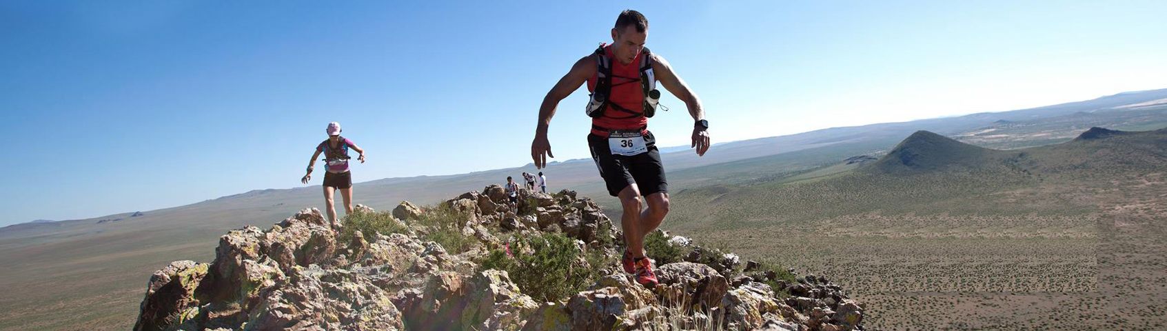
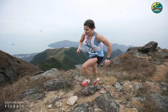
2021 - Lantau 50


Course 比賽路線
Please note under the current govt health restrictions, NO FOOD is allowed to be given out by the organizer, but water dispensors have permission so you must bring your own hydration system, flasks or water bottles for refilling water at checkpoints and at finish. Please bring enough food (or extra) to get you thru the course. Please bring enough water to start race to make it to first checkpoint.
Three distances 3個距離
54Km (54.8Km) - elevation gain 3130m & elevation loss 3130m (Max elev 934m) - 12 hour cut-off
27Km (27.3Km) - elevation gain 1777m & elevation loss 1720m (Max elev 934m) - 9 hour cut-off
16Km (16.5Km) - elevation gain 1004m & elevation loss 1009m (Max elev 684m) - 6 hour cut-off
54公里 (54.8公里) - 總爬升3130米,總下降3130米 (最高點 934米) – 限時 12小時
27公里 (27.3公里) - 總爬升1777米,總下降1720米 (最高點 934米) – 限時 9小時
16公里 (16.5公里) - 總爬升1004米,總下降1009米 (最高點 684米) – 限時 6小時
Start & Finish - Man Tung Road Park - (next to Novotel Hotel) - Tung Chung, Lantau Island, HONG KONG SAR
起點及終點 - 文東路公園 - (諾富特東薈城酒店隔鄰) - 東涌, 大嶼山, 香港
Course marking - 54km pink ribbons/pink signs / 27km starts with pink ribbons then after cp1 orange ribbons for 200 meters then pink after wisdom poles climbing Lantau Peak to finish / 16 km bright YELLOW ribbons from hospital bridge in Tung Chung to Wong Lung Hang stairs
Pink A4 size signs all distances
54km special note at Ngong Ping village - Strava map correct - when arriving at Ngong Ping village take right side road on Po Ngong Drive around the Ngong Ping cable car terminal staying right that goes 'around' the village to bus station and fastest direct route out to the main Ngong Ping road. Always an issue when marking.
54Km公里 (54.8Km公里)
UTMB Qualify race - Finisher of 54Km race can get 3 points for ITRA Endurance Point
UTMB 資格賽 - 完成54公里賽事可取得ITRA分數(ITRA Endurance Point) - 3分
Please find the details of certified tracks below. 有關認証路線請參閱以下連結。
Strava - https://www.strava.com/routes/19074083
https://tracedetrail.com/index.php/en/trace/trace/86749
Elevation gain 3240m & elevation loss 3232m (Max elev 934m) - 12 hour cut-off
總爬升3240米,總下降3232米 (最高點 934米) – 限時 12小時
Start time: 6:30AM
起步時間:早上6:30

|
From 由 |
To 去 |
Distance (km) 距離 (公里) |
Accu. Dist (Km) 累計距離 (公里) |
Elevation gain (M) 攀升 (米) |
Accu. Elevation Gain (M) 累計攀升 (米) |
Elevation Loss (M) 下降 (米) |
Accu. Loss (M) 累計下降 (米) |
|
Tung Chung 東涌 |
Ngong Ping 昂平 |
9.5 |
9.5 |
730 |
730 |
385 |
385 |
|
Ngong Ping 昂平 |
Kau Ling Chung Catchwater 狗嶺涌引水道 |
14.8 |
24.3 |
645 |
1375 |
977 |
1335 |
|
Kau Ling Chung Catchwater 狗嶺涌引水道 |
Shek Pik 石壁 |
7.8 |
32.1 |
320 |
1695 |
340 |
1675 |
|
Shek Pik 石壁 |
Pak Kung Au 伯公坳 |
9.6 |
41.7 |
875 |
2570 |
593 |
2268 |
|
Pak Kung Au 伯公坳 |
Pak Mong 白芒 |
9.1 |
50.9 |
560 |
3130 |
844 |
3112 |
|
Pak Mong 白芒 |
Tung Chung 東涌 |
3.8 |
54.8 |
110 |
3240 |
120 |
3232 |
|
CP 檢查點 |
Location 地點 |
Distance (Km) 距離 (公里) |
Cut Off Time 關門時間 |
Drink 飲品 |
Food (No food allowed for 2021) 食物 |
|
CP1 檢查點1 |
Ngong Ping 昂平 |
9.5 |
上午9:00AM (2Hr小時30Min分鐘) |
Water 水 |
|
|
CP2 檢查點2 |
Kau Ling Chung Catchwater 狗嶺涌引水道 |
24.3 |
下午12:00PM (5.5Hr小時30Min分鐘) |
Water 水 |
|
|
CP3 檢查點3 |
Shek Pik 石壁 |
32.1 |
下午1:00PM (6.5Hr小時30Min分鐘) |
Water 水 |
|
|
CP4 檢查點4 |
Pak Kung Au 伯公坳 |
41.7 |
下午3:30PM (9Hr小時) |
Water, 水, |
|
|
CP5 檢查點5 |
Pak Mong 白芒 |
50.9 |
下午5:30PM (11Hr小時) |
Water 水 |
|
|
Finish 終點 |
Tung Chung 東涌 |
54.8 |
下午6:30PM (12Hr小時) |
Water 水 |
27Km公里 (27.3Km公里)
UTMB Qualify race - Finisher of 27Km race can get 2 points for ITRA Endurance Point
UTMB 資格賽 - 完成27公里賽事可取得ITRA分數(ITRA Endurance Point) - 2分
Please find the details of certified tracks below. 有關認証路線請參閱以下連結。
Strava - 27km - https://www.strava.com/routes/19184602
https://tracedetrail.com/index.php/en/trace/trace/86746
Elevation gain 1922m & elevation loss 1908m (Max elev 934m) - 9 hour cut-off
總爬升1922米,總下降1908米 (最高點 934米) – 限時 9小時

|
From 由 |
To 去 |
Distance (km) 距離 (公里) |
Accu. Dist (Km) 累計距離 (公里) |
Elevation gain (M) 攀升 (米) |
Accu. Elevation Gain (M) 累計攀升 (米) |
Elevation Loss (M) 下降 (米) |
Accu. Loss (M) 累計下降 (米) |
|
Tung Chung 東涌 |
Ngong Ping 昂平 |
9.5 |
9.5 |
730 |
730 |
385 |
385 |
|
Ngong Ping 昂平 |
Pak Kung Au 伯公坳
|
4.8 |
14.3 |
465 |
1195 |
465 |
850 |
|
Pak Kung Au 伯公坳 |
Pak Mong 白芒 |
9.1 |
23.5 |
617 |
1812 |
938 |
1788 |
|
Pak Mong 白芒 |
Tung Chung 東涌 |
3.8 |
27.3 |
110 |
1922 |
120 |
1908 |
|
CP 檢查點 |
Location 地點 |
Distance (Km) 距離 (公里) |
Cut Off Time 關門時間 |
Drink 飲品 |
Food (No food allowed 2021) 食物 |
|
CP1 檢查點1 |
Ngong Ping 昂平 |
9.5 |
上午1 (3Hr小時15Min分鐘) |
Water 水 |
|
|
CP4 檢查點4 |
Pak Kung Au 伯公坳 |
14.3 |
下午1 (5Hr小時15Min分鐘) |
Water 水, |
|
|
CP5 檢查點5 |
Pak Mong 白芒 |
23.5 |
下午3 (7Hr小時30Min分鐘) |
Water 水 |
|
|
Finish 終點 |
Tung Chung 東涌 |
27.3 |
下午 (9Hr小時) |
Water 水 |
|
16Km公里 (16.5Km公里)
Elevation gain 1004m & elevation loss 1009m (Max elev 684m) - 6 hour cut-off
總爬升1004米,總下降1009米 (最高點 684米) – 限時 6小時
Strava 16km - https://www.strava.com/routes/19185985

|
From 由 |
To 去 |
Distance (km) 距離 (公里) |
Accu. Dist (Km) 累計距離 (公里) |
Elevation gain (M) 攀升 (米) |
Accu. Elevation Gain (M) 累計攀升 (米) |
Elevation Loss (M) 下降 (米) |
Accu. Loss (M) 累計下降 (米) |
|
Tung Chung 東涌 |
Pak Mong 白芒 |
12.7 |
12.7 |
894 |
894 |
889 |
889 |
|
Pak Mong 白芒 |
Tung Chung 東涌 |
3.8 |
16.5 |
110 |
1004 |
120 |
1009 |
|
CP 檢查點 |
Location 地點 |
Distance (Km) 距離 (公里) |
Cut Off Time 關門時間 |
Drink 飲品 |
Food (No food allowed 2021) 食物 |
|
CP5 檢查點5 |
Pak Mong 白芒 |
12.7 |
上午 (4Hr小時) |
Water 水 |
|
|
Finish 終點 |
Tung Chung 東涌 |
16.5 |
下午 (6Hr小時) |
Water 水 |
|
HOW to go to CP3 from Start / Finish 如何從起點/終點前往檢查點3
Click here for detailed google map instruction 按此Google地圖前往指示
Exact CP3 location 檢查點3位置
Click here for google map exact location按此Google地圖正確位置
HOW to go to CP4 from Start / Finish 如何從起點/終點前往檢查點4
Click here for detailed google map instruction 按此Google地圖前往指示
Course Designer:
Designed by Michael Maddess (Race Director & Course Designer) who's organized over 280 events with Action Asia Events and one of the most experienced Race Directors in Asia with a wealth of experience. Michael Maddess an active trail runner, originally from Vancouver, Canada who was Race Director of the World Police Fire Games Triathlon in Canada before moving to Asia, organizes the Action Asia 50 series in Hong Kong (4 races), Taiwan, Thailand, Malaysia, Singapore, 3 day 100km ultra marathon stage events in Mongolia, Nepal, Kazakhstan, Yunnan/Sichuan China, Vietnam and Laos, has organized over 17 Action Asia Challenge adventure races across Asia including Singapore, Malaysia, Taiwan & HK, 2 Vietnam adventure races, 2 Nepal Himalayan Mountain Bike races, over 30 Action SPRINT HK adventure races, 8 Action Asia Off Road HK bike races, worked/competed in numerous other road races/triathlons including finishing 3 Ironman triathlons (10hrs 46min), 1st runner-up in 100km Oxfam trailwalker in 11hrs 16min (record for HK resident) 3x in 13 hrs 25 min, 12hrs 44min, 12hrs 39min, winning team Wilson Trail full & half 5x (78km - 10hr14min), 3rd in HK100 (1st edition) in 12hrs 30min, winner of Sabah 3 day adventure race 3x, 8th overall Gobi 250km race suffering from hypothermia and still holds a couple KOTH HK marathon records. He's also coached dragonboat, soccer and baseball teams, climbed to 16,000+ft in Bhutan, 15,000+ft Nepal Annapurna Basecamp, made it up to 5000m 4Sisters in Sichuan within 24hrs of getting off plane (not recommended) and free jumps off high bridges in Nepal for fun. If he's not outside designing a course, doing something extreme, he's not having fun.
Cut-offs are subject to race discretion on race day as Race Director has final say.
關門時間 – 賽事總監在比賽當日擁有最終決定櫂
Insurance - The event has its own public liability insurance coverage, but we recommend that all participants get their own personal accident coverage to cover any personal accidents.
保險 – 本活動已購買公眾責任保險,但建議所有參加者購買個人意外保險以保障任何個人意外。
Medical - As this event involves going into the mountains we recommend all participants to have gone to a medical checkup before the event to make sure you are physically fit enough to handle this kind of physical challenge.
醫療 – 由於活動於山上進行,建議所有參加者進行醫療檢查,以確保身體狀況能應付有關挑戰。


/ITE26-Banner300x100.jpg)
/CBREMKC_9735_HK_Logo web banner-01.jpg)
/RoyalInt300100banner.jpg)
/HysanWebBannerDesign300.png)