13 Nov, 2022
Finished
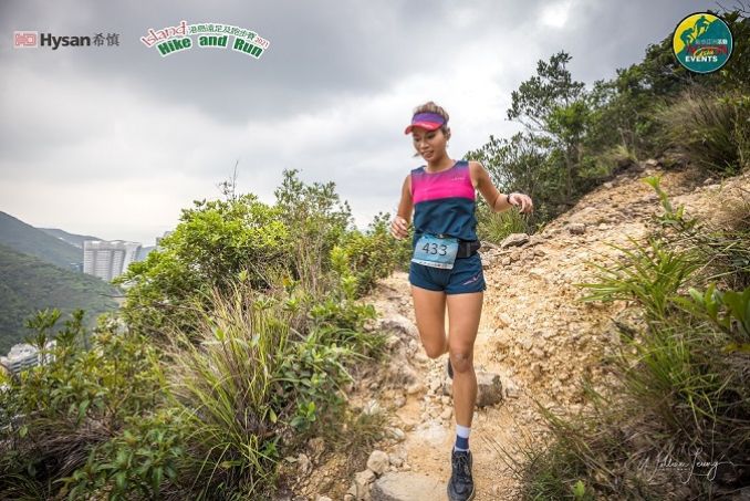
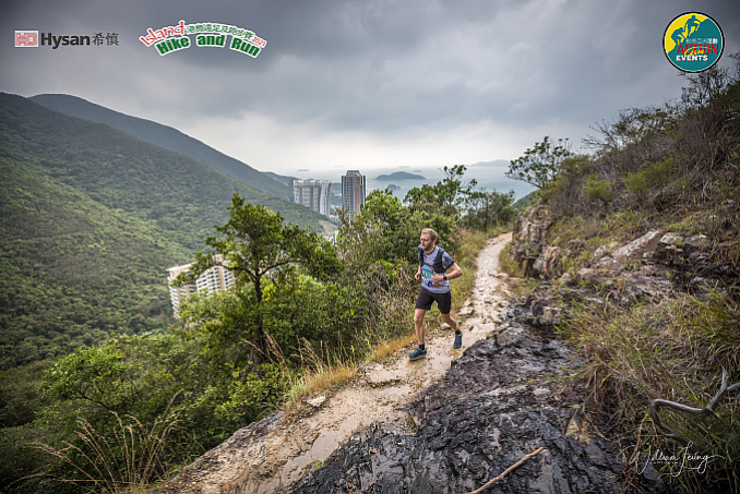
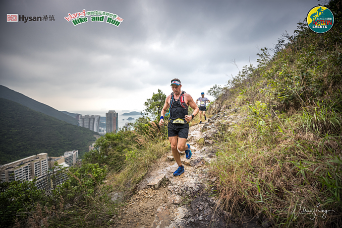
2022 - HYSAN Island Hike & Run


Course 比賽路線
BANANAS at check points - first time in 3 yrs so enjoy.
Three distances 3個距離
22Km (22.4Km) - elevation gain 1039m & elevation loss 1039m (Max elev 433m) - 6.5 hour cut-off
14Km (14.6Km) - elevation gain 681m & elevation loss 681m (Max elev 433m) - 5.5 hour cut-off
5Km (5.4Km) - elevation gain 390m & elevation loss 390m (Max elev 436m) - 3 hour cut-off
22公里 (22.4公里) - 總爬升1039米,總下降1039米 (最高點 433米) – 限時 6.5小時
14公里 (14.6公里) - 總爬升681米,總下降681米 (最高點 433米) – 限時 5.5小時
5公里 (5.4公里) - 總爬升390米,總下降390米 (最高點 436米) – 限時 3小時
Organizer has the right to make changes to the course including the start/finish area if needed.
主辦機構如有需要,有權更改路線,包括起點/終點。
Course links:
Please use the strava track for the most accurate course especially after cp1 to the Tai Tam reservoir as small shortcut allowed before Tai Tam dam which saves 100-200m which can see on strava but not on old maps posted below.
22 km - Strava link https://www.strava.com/routes/19230346
22 km - gpx file
14 km - Strava link https://www.strava.com/routes/19230623
14 km - gpx file
5 km - Strava link https://www.strava.com/routes/19230780
5 km - gpx file
22Km公里 (22.4Km公里)
22 km
Green Lane Service Reservoir Sitting-Out Area -> Green Lane -> Blue Pool Road -> Left turn go to stairs linking Blue Pool Road and Tai Hang Road -> Tai Hang Road -> Blue Pool Road -> Go to stairs linking Blue Pool Road and Wong Nai Chung Gap Road -> Wong Nai Chung Gap Road -> Tai Tam Reservoir Road -> Tsz Lo Lan Shan Path -> Tze Kong Bridge -> The Twins Catch Water -> Left turn to Wilson Trail Section 1 (The Twins) -> Tze Kong Bridge -> Path linking between Tze Kong Bridge and Tai Tam Reservoir Road -> Turn left to Tai Tam Reservoir Road -> Tai Tam Tuk Reservoir Mansonry Bridge -> CP1 at the BBQ area on Tai Tam Reservoir Road -> Tai Tam Reservoir Dam -> Mount Parker Road -> Hong Kong Forest Track – Boa Vista Track Section -> Boa Vista -> CP2 at Tai Fung Au -> Hong Kong Trail Section 5 -> Tai Tam Country Trail -> Tai Hang Road -> Go to stairs linking Blue Pool Road -> Blue Pool Road -> Green Lane -> Green Lane Service Reservoir Sitting-Out Area
22公里
箕璉坊配水庫休憩處 -> 箕璉坊 -> 藍塘道 -> 連接藍塘道及大坑道的樓梯 -> 大坑道 -> 藍塘道 -> 連接藍塘道及黃泥涌峽道的樓梯 -> 黃泥涌峽道 -> 大潭水塘道 -> 紫羅蘭山徑 -> 紫崗橋 -> 孖崗山引水道 -> 轉左衛奕信徑1段(孖崗山) ->紫崗橋 -> 連接紫崗橋及大潭水塘道的山徑 -> 轉左至大潭水塘道 -> 大潭篤水塘石橋 -> 檢查站1 (大潭水塘道燒烤區) -> 大潭水塘水壩 -> 柏架山道 -> 港島林道-美景路段 -> 野豬徑 ->檢查站2 (大風坳) ->港島徑5段 -> 大潭郊遊徑 ->大坑道 -> 連接藍塘道及大坑道的樓梯 -> 藍塘道 -> 箕璉坊 ->箕璉坊配水庫休憩處
ITRA Qualify race - Finisher of 22Km race can get 1 point for ITRA Endurance Point
ITRA 資格賽 - 完成22公里賽事可取得ITRA分數(ITRA Endurance Point) - 1分
Please use the strava track for the most accurate course especially after cp1 to the Tai Tam reservoir.


Please use the strava track for the most accurate course especially after cp1 to the Tai Tam reservoir.
|
From 由 |
To 去 |
Distance (km) 距離 (公里) |
Accu. Dist (Km) 累計距離 (公里) |
Elevation gain (M) 攀升 (米) |
Accu. Elevation Gain (M) 累計攀升 (米) |
Elevation Loss (M) 下降 (米) |
Accu. Loss (M) 累計下降 (米) |
|
Green Lane Service Reservoir Sitting-Out Area 箕璉坊配水庫休憩處 |
Tai Tam Reservoir Road 大潭水塘道 |
12.2 |
12.2 |
662 |
662 |
718 |
718 |
|
Tai Tam Reservoir Road 大潭水塘道 |
Quarry Gap 大風坳 |
5.6 |
17.8 |
352 |
1014 |
63 |
781 |
|
Quarry Gap 大風坳 |
Green Lane Service Reservoir Sitting-Out Area 箕璉坊配水庫休憩處 |
4.8 |
22.4 |
271 |
1285 |
492 |
1273 |
|
CP 檢查點 |
Location 地點 |
Distance (Km) 距離 (公里) |
Cut Off Time 關門時間 |
Drink 飲品 |
Food (tbc) 食物 (tbc) |
|
CP1 檢查點1 |
Tai Tam Reservoir Road 大潭水塘道 |
12.2 |
上午11:40AM (3Hr小時) |
Water 水 |
No food No food |
|
CP2 檢查點2 |
Quarry Gap 大風坳 |
17.8 |
下午1:10PM (4.5Hr小時) |
Water 水 |
No food No food |
|
Finish 終點 |
Green Lane Service Reservoir Sitting-Out Area 箕璉坊配水庫休憩處 |
22.4 |
下午3:10PM (6.5Hr小時) |
Water 水 |
No food |
14 Km公里 (14.6Km公里)
14Km
Green Lane Service Reservoir Sitting-Out Area -> Green Lane -> Blue Pool Road -> Left turn go to stairs linking Blue Pool Road and Tai Hang Road -> Tai Hang Road -> Blue Pool Road -> Go to stairs linking Blue Pool Road and Wong Nai Chung Gap Road -> Wong Nai Chung Gap Road -> Tai Tam Reservoir Road -> Tsz Lo Lan Shan Path -> Tze Kong Bridge -> Path linking between Tze Kong Bridge and Tai Tam Reservoir Road -> Turn left to Tai Tam Reservoir Road -> Tai Tam Tuk Reservoir Mansonry Bridge -> CP1 at the BBQ area on Tai Tam Reservoir Road -> Tai Tam Reservoir Dam -> Mount Parker Road (Hong Kong Trail Section 6) -> CP2 at Tai Fung Au -> Hong Kong Trail Section 5 -> Tai Tam Country Trail -> Tai Hang Road -> Go to stairs linking Blue Pool Road -> Blue Pool Road -> Green Lane -> Green Lane Service Reservoir Sitting-Out Area
14公里
箕璉坊配水庫休憩處 -> 箕璉坊 -> 藍塘道 -> 連接藍塘道及大坑道的樓梯 -> 大坑道 -> 藍塘道 -> 連接藍塘道及黃泥涌峽道的樓梯 -> 黃泥涌峽道 -> 大潭水塘道 -> 紫羅蘭山徑 -> 紫崗橋 -> -> 連接紫崗橋及大潭水塘道的山徑 -> 轉左至大潭水塘道 -> 大潭篤水塘石橋 -> 檢查站1 (大潭水塘道燒烤區) -> 大潭水塘水壩 -> 柏架山道(港島徑6段) -> ->檢查站2 (大風坳) ->港島徑5段 -> 大潭郊遊徑 ->大坑道 -> 連接藍塘道及大坑道的樓梯 -> 藍塘道 -> 箕璉坊 ->箕璉坊配水庫休憩處
Please use the strava track for the most accurate course especially after cp1 to the Tai Tam reservoir.

Please use the strava track for the most accurate course especially after cp1 to the Tai Tam reservoir.
|
From 由 |
To 去 |
Distance (km) 距離 (公里) |
Accu. Dist (Km) 累計距離 (公里) |
Elevation gain (M) 攀升 (米) |
Accu. Elevation Gain (M) 累計攀升 (米) |
Elevation Loss (M) 下降 (米) |
Accu. Loss (M) 累計下降 (米) |
|
Green Lane Service Reservoir Sitting-Out Area 箕璉坊配水庫休憩處 |
Tai Tam Reservoir Road 大潭水塘道 |
6.8 |
6.8 |
239 |
239 |
235 |
235 |
|
Tai Tam Reservoir Road 大潭水塘道 |
Quarry Gap 大風坳 |
3.2 |
10.0 |
299 |
538 |
137 |
372 |
|
Quarry Gap 大風坳 |
Green Lane Service Reservoir Sitting-Out Area 箕璉坊配水庫休憩處 |
4.8 |
14.6 |
271 |
812 |
492 |
801 |
|
CP 檢查點 |
Location 地點 |
Distance (Km) 距離 (公里) |
Cut Off Time 關門時間 |
Drink 飲品 |
Food (tbc) 食物 (tbc) |
|
CP1 檢查點1 |
Tai Tam Reservoir Road 大潭水塘道 |
6.8 |
上午11:10AM (2.5Hr小時) |
Water 水 |
No food |
|
CP2 檢查點2 |
Quarry Gap 大風坳 |
10.0 |
下午12:10PM (3.5Hr小時) |
Water 水 |
No food |
|
Finish 終點 |
Green Lane Service Reservoir Sitting-Out Area 箕璉坊配水庫休憩處 |
14.8 |
下午2:10PM (5.5Hr小時) |
Water 水 |
No food |
5Km公里 (5.4Km公里)
5Km
Green Lane Service Reservoir Sitting-Out Area -> Green Lane -> Blue Pool Road -> Left turn go to stairs linking Blue Pool Road and Tai Hang Road -> Tai Hang Road -> Blue Pool Road -> Go to stairs linking Blue Pool Road and Wong Nai Chung Gap Road -> Wong Nai Chung Gap Road -> Tai Tam Reservoir Road -> Right turn near Wong Nai Chung Reservoir Park to Tai Tam Country Trail -> Turn left at Wilson Trail Section 1 -> Tai Tam Country Trail -> Tai Hang Road -> Go to stairs linking Blue Pool Road -> Blue Pool Road -> Green Lane -> Green Lane Service Reservoir Sitting-Out Area
5公里
箕璉坊配水庫休憩處 -> 箕璉坊 -> 藍塘道 -> 連接藍塘道及大坑道的樓梯 -> 大坑道 -> 藍塘道 -> 連接藍塘道及黃泥涌峽道的樓梯 -> 黃泥涌峽道 -> 大潭水塘道 -> 於黃泥涌水塘公園前右轉至大潭郊遊徑 -> 左轉至轉左衛奕信徑1段 -> 大潭郊遊徑 ->大坑道 -> 連接藍塘道及大坑道的樓梯 -> 藍塘道 -> 箕璉坊 ->箕璉坊配水庫休憩處

|
From 由 |
To 去 |
Distance (km) 距離 (公里) |
Accu. Dist (Km) 累計距離 (公里) |
Elevation gain (M) 攀升 (米) |
Accu. Elevation Gain (M) 累計攀升 (米) |
Elevation Loss (M) 下降 (米) |
Accu. Loss (M) 累計下降 (米) |
|
Green Lane Service Reservoir Sitting-Out Area 箕璉坊配水庫休憩處 |
Park View 陽明 |
3.6 |
3.6 |
331 |
331 |
158 |
158 |
|
Park View 陽明 |
Green Lane Service Reservoir Sitting-Out Area 箕璉坊配水庫休憩處 |
1.8 |
5.4 |
27 |
358 |
192 |
350 |
|
CP 檢查點 |
Location 地點 |
Distance (Km) 距離 (公里) |
Cut Off Time 關門時間 |
Drink 飲品 |
Food (tbc) 食物 |
|
CP3 檢查點3 |
Park View 陽明 |
3.6 |
上午11:10AM (2.5Hr小時) |
Water 水 |
No food |
|
Finish 終點 |
Green Lane Service Reservoir Sitting-Out Area 箕璉坊配水庫休憩處 |
5.4 |
上午11:40AM (3Hr小時) |
Water 水 |
No food |
Course Designer:
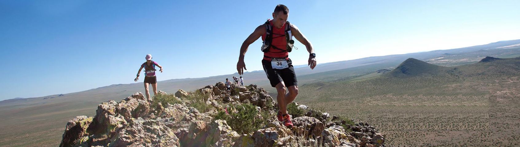
Designed by Michael Maddess (Race Director & Course Designer) who's organized over 280 events with Action Asia Events and one of the most experienced Race Directors in Asia with a wealth of experience. Michael Maddess an active trail runner, originally from Vancouver, Canada who was Race Director of the World Police Fire Games Triathlon in Canada before moving to Asia, organizes the Action Asia 50 series in Hong Kong (4 races), Taiwan, Thailand, Malaysia, Singapore, 3 day 100km ultra marathon stage events in Mongolia, Nepal, Kazakhstan, Yunnan/Sichuan China, Vietnam and Laos, has organized over 17 Action Asia Challenge adventure races across Asia including Singapore, Malaysia, Taiwan & HK, 2 Vietnam adventure races, 2 Nepal Himalayan Mountain Bike races, over 30 Action SPRINT HK adventure races, 8 Action Asia Off Road HK bike races, worked/competed in numerous other road races/triathlons including finishing 3 Ironman triathlons (10hrs 46min), 1st runner-up in 100km Oxfam trailwalker in 11hrs 16min (record for HK resident) 3x in 13 hrs 25 min, 12hrs 44min, 12hrs 39min, winning team Wilson Trail full & half 5x (78km - 10hr14min), 3rd in HK100 (1st edition) in 12hrs 30min, winner of Sabah 3 day adventure race 3x, 8th overall Gobi 250km race suffering from hypothermia and still holds a couple KOTH HK marathon records. He's also coached dragonboat, soccer and baseball teams, climbed to 16,000+ft in Bhutan, 15,000+ft Nepal Annapurna Basecamp, made it up to 5000m 4Sisters in Sichuan within 24hrs of getting off plane (not recommended) and free jumps off high bridges in Nepal for fun. If he's not outside designing a course, doing something extreme, he's not having fun.


/ITE26-Banner300x100.jpg)
/CBREMKC_9735_HK_Logo web banner-01.jpg)
/RoyalInt300100banner.jpg)
/HysanWebBannerDesign300.png)